

A Place on the Planet
Some 12,000 years ago the last Ice Age ended. The ice-caps melted away and a green blanket of dense forests covered North-West Europe. Extensive deciduous woods determined the landscape, the culture and the economy, also in the region that we today call Flanders.
Both hunter-gatherers and farmers made ample use of the forest, where they found food, building materials and fuel. People gathered there to perform rituals. When in the Roman period, at the beginning of our era, there was a marked growth in the population and hence also in the demands for wood and agricultural land, the area of forest shrank. Still, woods continued to dominate the look of the region.
In the Middle Ages, the long period from 500 to 1500, the landscape underwent more definitive, drastic changes. The rise of the towns and the strong development of agriculture led to intensive tree-felling. By the 13th century the area of forest had reached a historic low point.

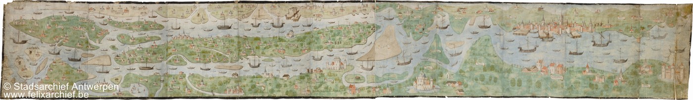
Bruges, Musea Brugge, Groeningemuseum
At the end of the Middle Ages the area around Bruges was a tangle of dikes, roads, habitation and tidal channels. Remaining section of the Heraldic Map of the Brugse Vrije by Pieter Pourbus (1561-1571).
A Hub for People and Goods
Through the area on the North Sea ran a wide-branching network of rivers. For the transport of people and goods those watercourses were for a long time much more important than overland routes. The rivers and the sea linked the region economically and culturally with other parts of Europe and the world.
Besides the rivers the soil and the relief determined human beings’ freedom of action. The diversity of soils favoured district-bound specialisation. Wheat thrived on rich loamy soils, pigs were fed in oak woods, sheep were kept on salty or sandy ground and forestry and peat-digging were also of great importance. Although the many watercourses ensured cultural and economic exchange, many areas retained their unique characteristics because the soil and the relief were so decisive.
From the Middle Ages on human beings set their stamp more and more emphatically on the landscape. The interaction between man and nature created cultural landscapes like the Campine, the Hageland, the Maasland, Haspengouw and the coastal polders. All those areas owe their unique quality both to the landscape elements present and to the traces of human intervention, such as the building of roads, the erection of buildings or the joint management of common lands.
Focal points
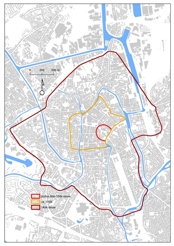
Ghent, Dienst voor stadsarcheologie
Ground plan of Ghent, showing the development of the ramparts. In the 13th century, after Paris, Ghent was the largest city north of the Alps.
A Region of Towns
In the Roman period North-West Europe experienced a first population peak and towns like Tongeren and Tournai were founded. Still, most residential locations were small and were lost after the population peak subsided.
Between 950 and 1300 Europe experienced a new period of constant population growth. The population tripled, and in the Low Countries there was actually a four-fold increase. That increase left the countryside with a population surplus. For that reason many children of farmers made for the burgeoning towns, where they could often find employment in the thriving cloth industry. The flight from the countryside made the towns grow from 1000 onwards and their number also increased. That evolution took place all over North-West Europe, but nowhere was the concentration of towns and town-dwellers as great as in the southern parts of the Low Countries.
The medieval urbanisation had a great impact on the landscape. Towns themselves became determining landscape elements. In addition, they needed increasing amounts of building materials, food, fuel and other raw materials. In this way in the Middle Ages wooded Flanders became an intensely urbanised region. The concentration of towns with a medieval ground plan, despite the radical changes of the last two centuries is still to a large extent visible in the present-day landscape.

Belga Image, 315556
In Raversijde near Ostend archaeologists discovered the oldest known dike on the Flemish North Sea coast. The embankment dates from the Roman period and is recognisable from the slanting blocks of clay and turf which served as the front of the dike.
Working with Water
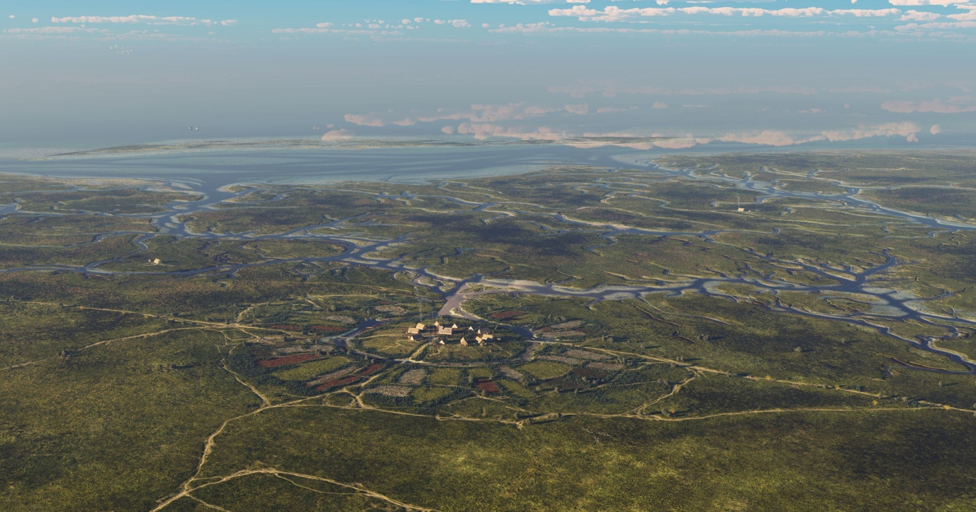
While in the interior humans made headway against the forest, the inhabitants of the coast made ample use of the opportunities afforded by the sea. As early as the Roman period they experimented with dikes and dwellings on mounds. At the end of the Roman period the influence of the action of the tides on the landscape increased. At high tide the seawater penetrated far inland. In the early Middle Ages the tidal channels silted up again through natural deposits and the coastal strip became more attractive to man. Originally it was mainly shepherds who used the area and also independent farmers living on mounds or on the dry zones on the edge of the coastal plain.
In around 1000 after the communities of independent farmers, the counts of Flanders also discovered the economic potential of the coast. Together with a number of abbeys they had dikes built on a large scale. The former mud flats and salt marshes were transformed into a polder area with fertile fields, peat bogs and meadows.
The reclaimed land was not necessarily regained for ever. Sometimes wars and flood tides caused serious damage to dikes, so that enclosed areas found themselves under water again. The inhabitants of the Low Countries by the sea had, however, grown into good dike-builders.
Discover more on this topic
Dwars door de Lage Landen – De Vlaamse polders
Non-fiction
Perspectieven op het landschap. Achtergronden om landschappen te lezen en te begrijpen
Academia Press, 2007
Miradal: Erfgoed in Heverleebos en Meerdaalwoud
Davidsfonds, 2009
Geschiedenis van de Nederlanden
HB Uitgevers, 2012
Gent. Stad van alle tijden
Mercatorfonds 2016
De Graven van Vlaanderen (861-1384)
Davidsfonds, 2019
De geschiedenis van België in 100 oude kaarten
Lannoo, 2021
De landschappen van Vlaanderen en Zuidelijk Nederland. Een landschapsecologische studie
Garant, 1993
Aan de rand van de wereld. Hoe de Noordzee ons vormde
De Bezige Bij, 2020
Bossen van Vlaanderen. Een historische ecologie
Davidsfonds, 1993
Landschap en landbouw in middeleeuws Vlaanderen
Gemeentekrediet, 1995